
Turner Ridge Property Mississippi Valley Type Pb-Zn
|

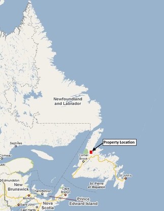
The Turner Ridge property is located 65km NE of Deer Lake on the west side of White Bay in north central Newfoundland. Access is via Route 420 north from the TCH towards the community of Sop’s Arm. Route 420 has been recently straightened and it now passes through the center of the property.
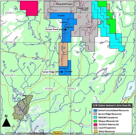
Electrical power lines run through the center of the property and abundant sources of water exist within the property and the local area. The region and the province has a long historty and culture of mining and development. The property consists of 14 map staked claims contained in two licenses covering 350 hectares. The claims are in good standing. Exploration expenditures of only $2800.00 are required on the claims prior to March 31 2015. The claim license numbers are 021823M and 021860M. |

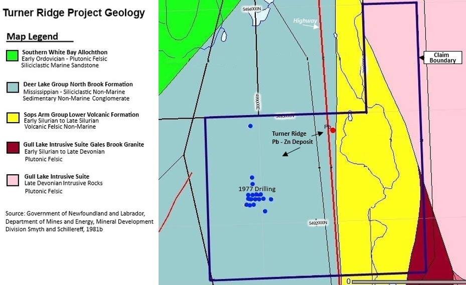
The Turners Ridge area of western Newfoundland lies at the northern terminus of the Carboniferous Deer Lake Basin, these sediments sit unconformably upon the Precambrain gneissic complexes (Grenvillian Inlier) which forms the backbone of the Great Northern Peninsula. The Carboniferous rocks were deposited in extentional jogs along wrench faults which created a 4000 sq km intermontane rift in western Newfoundland and occupy a broad, nearly flat synclinal sequence in the Deer Lake and White Bay areas.
The oldest basin fill rocks are of the Anguille Group which sits in angular unconformity with the overlying Deer Lake Group and the underlying Precambrian basement. In most places the Anguille Group lies unconformably upon Precambrian basement rocks whereas the younger overlying Deer Lake Group lies unconformably on the Anguille Group but can also lie unconformably upon the Precambrian basement. Rocks of the Deer Lake Group occur in two major northeast-southwest trending synclinal folds probably the result of dip slip movements on major northeast faults. The older Precambrian basement consists largely of granitic gneisses. The Lead – Zinc prospect is hosted by carboniferous limestone and can be described as a Mississippi Valley type deposit and may be analogous to the Gary’s River deposit in Nova Scotia. Large areas of poorly exposed, poorly explored carboniferous rocks in two sedimentary basins in Western Newfoundland could host similar or larger Pb (-Zn) deposits. (Keats 2009) |
|
|
Strike-slip faults are common throughout the area. They strike generally northeast and displacement is less than 300 metres. The Cabot Fault which forms the boundary between the Lomond and Hampden zones is in the general vicinity of the showing and possibly played a role in mineralization, as Mississippi Valley type deposits are often found near major regional faults. The host Silurian rocks are thrust over the footwall Carboniferous strata.
|
Peter Dimmell P.geo did and air photo interpretation using 1994 vintage color air photos at 1:12,500 scale, which were acquired from the NL air photo library as good quality color copies. |

Galena is the dominant economic mineral. It is usually fine- grained but where it forms a fracture stockwork in the matrix of dolomite breccias it is medium grained. It also occurs in veinlets with barite, pyrite (or marcasite) and very minor sphalerite and chalcopyrite. White and pink massive barite with a sucrosic texture occurs as walls around a core of galena, as well as the reverse. Pyrite, as veins and disseminations, can occur alone, with galena or (rarely) with barite.Solution cavities are filled with calcite and clear, white or red silica. Localized reefs or banks are minerlizaed topographic highs.
At the Turners Ridge showing Dimmell (1979) reported an unofficial resource of 200,000 tons grading 3‐4% Lead. In a later report by Kevin Keats (2004) he describes the Turner Ridge Lead prospect has having an unofficial resource estimate of 250,000 tons grading 4.5% Pb. Diamond drilling carried out in 1977 returned significant high grade mineralization interceptions, such as 5.92% Pb over 21.7 M (70.5ft), 5.32 % Pb, 0.12% Zn and 12.6 g/t Ag over 17.7m (57.5ft) Including 13.9% Pb, 0.34 % Zn and 17.6 g/t Ag over 3.1M and 18.2% Pb over 1.54M. Prospecting in the fall of 2003 turned up new significant zinc values up to 3.55% with several being in the 0.5% - 1.0% range. One sample ran as high as 10.15% lead. Given the results for 5 days prospecting we think that the potential to upgrade the lead - zinc values are excellent. Prospecting during the 2004 season confirmed the lead and zinc mineralization. Values as high as 2.18% Zn and 4.00% Pb were returned with several being in the range of 0.51% - 2.18% Zn and 0.85% - 4.00% Pb. The 2007 drilling just north of Turner Ridge prospect by Spruce Ridge Resources was successful in intersecting significant lead as well as associated zinc over widths up to 12.6 meters averaging 3.65% Pb and 0.19% Zn and based on these results, additional drilling was recommended however none was carried out. 
We have assembled all available assessment reports filed for past exploration work conducted on the property and a large amount of data that covers the region.
In 2008 Spruce Ridge Resources Ltd contracted Novatem Inc to complete a 9,415 line kilometer helicopter borne radiometric and magnetic survey over their entire land holdings in the Deer Lake Basin including the Turner Ridge Lead prospect. The full survey data is available for review. Past reports on ground based EM, Mag, IP Survey’s, soil geochem, geological mapping and diamond drilling work performed by Noranda, Spruce Ridge, Brinex and other companies are also available. |
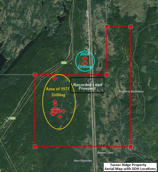
Aerial map of Turner Ridge claims
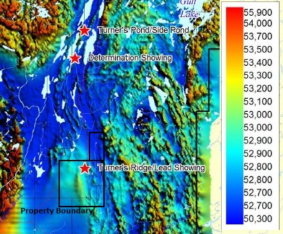
Reduced image of aerial magnetic map 2008
This property could be combined with our 1150 hectare Taylors Pond Gold, Lead and Uranium property located 3 kilometers north. Additional existing claims may also be available from an associate and it can also be expanded by new claimstaking. |

Our team delivers intelligent, lower risk exploration solutions and property acquistion alternatives to the exploration industry
